Specifications - state map portfolios
Each state portfolio for MHM-USA Version 1 contains 8 map files:
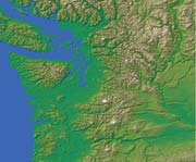
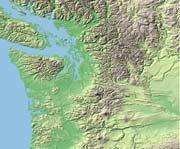
Four color relief map styles in JPEG format, RGB 24 bits per pixel,
300 pixels per inch. The color schemes feature a Cartographic map
elevation color scheme in striking contour banding colors, a Natural
Look more suitable for background draped texture with high information
density overlays, a High-Contrast version with a dramatic color
variation between high and low altitudes, and a Low-Contrast style
suitabe for muted backgrounds.
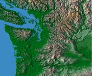

Cartographic Style
Natural Look Style
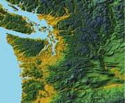
High-Contrast Style
Low-Contrast Style
One grayscale relief map is supplied in 8 bit Grayscale, 300 pixels
per inch, exactly the same size and coordinates. This map style is provided
for designers who wish to generate color scheme to match a custom house
or corporate style and customize their own relief map images.
A bitmap mask (black & white) of the state outline is provided to
enable the state relief to be extracted from the above colorized or grayscale
relief images - the mask allows either the state area, or by inverting,
the non-state area to be selected using Photoshop Channels, manipulated,
screened, or deleted. Using the mask is discussed in the Photoshop
section of this user guide.
Two vector files are provided both in Illustrator AI or Illustrator
EPS format. The map features are presented on individual layers and include
coastlines, rivers, interstate and major road systems, railroads, county,
state and international borders, town locations, town names text, latitude
and longitude grids and relief layer. Each layer can be selectively
switched on or off as needed for your map customization, edited as required,
level sequence within the layers may be altered, and new layers may be
added. The vector maps may be edited, either as individual layers or
multiple layers together, giving clients the option to change line widths
and color, font styles and colors, and allowing the placement of any of
the 4 colorized relief maps, or customized grayscale relief map, as the
bottom relief layer.
Typical range of uses
The versatility of the MHM-USA state maps collection lends itself to a
wide number of uses either as ready to use detailed maps or as sophisticated
customized products. A wide range of uses include all the traditional
publishing areas from newspapers, magazines, books, educational products
to web and multimedia, television and video.
Using MHM-USA with Illustrator (separate section)
Using MHM-USA with Photoshop (separate section)
Licensing information
The Mountain High Maps USA Relief map collection is published by Digital
Wisdom with the intent that it will be used royalty-free by graphic designers,
authors, producers, publishers as part of a publication for commercial
use. There are very few restrictions in normal use and any limitations
imposed are intended to prevent the over-exploitation of this resource
beyond a reasonnable and fair use criteria. See the
licensing page for the full license.
We have summarized the licensing areas with potential limitations
and you should contact
Digital Wisdom about further use of the product
- in some cases additional licensing may be applicable, or restrictions
may be waived according to the circumstances:
Multiple workstation use or network use
Atlas use or use in excess of 25% content of a publication
Publisher using the maps in more than 5 published titles
Freelance use greater than 5 customers
Freelance use greater than 10 maps per client
Television broadcast audience greater than 10 states
Resold artwork where image exceeds 25% of product image
Posters, postcards and t-shirts high volume usage
Multiple web domains
Web use in excess of 25 web pages
Multimedia application produced in excess of 10,000 copies
Web or multimedia access to unmodified maps by third-parties

USA Relief Maps ~ Digital Wisdom Inc ~ PO Box 11 ~ Tappahannock VA 22560 ~ USA
800-800-8560 | 804-443-9000 | Email
© Digital Wisdom, Inc.
Any comments or problems with this site? Please let us know - thank you!

